Sunset in Bud Bongao
Bud Bongao during sunrise
I thank the followers of Sultan Kiram for the rare chance to visit Tawi-tawi province, the southernmost part of the Philippines.
Due to the Sabah crisis which was caused by the hostilities in the contested territory in Eastern Borneo, I was sent to see the situation of our people in the affected areas.
Due to the Sabah crisis which was caused by the hostilities in the contested territory in Eastern Borneo, I was sent to see the situation of our people in the affected areas.
"You need to go to Tawi-tawi to assess the situation there," was the order given by my boss.
Well, it was not a job for me. It was like ordering Portuguese navigator Ferdinand Magellan to discover the spice islands somewhere in the Pacific ocean.
I liked the job because it gave me the opportunity to see new places and meet more friends.
I liked the job because it gave me the opportunity to see new places and meet more friends.
I was always excited to see Tawi-tawi, a quiet and peaceful province south of Sulu province.
Due to its peace and tranquility, I never had the chance to visit this place during my younger days as a warrior of the First Scout Ranger Regiment.
Most of the violent armed groups can be found in the island provinces of Sulu and Basilan. Owing to its proximity to the two famous neighboring islands, Tawi-tawi is sometimes wrongly associated to the bad reputation gained by the former.
Tawi-tawi's capital town is Bongao. It is the land swarmed by motorcycles. You seldom find 4-wheeled vehicles in the town. Most of the cars are owned by government agencies, local government officials and wealthy business men.
As I roamed around Bongao, I can't help but appreciate the beauty of the towering figure which serves as a historical landmark in the island. It is a reference point for seafarers since the ancient times.
The people of Tawi-tawi are very proud of its sacred mountain, Bud Bongao.
"You must climb Bud Bongao if you want to have a better view of Sibutu, Simunul and even Sabah," said Mohammad, a tricycle driver.
As a soldier, I always prefer higher grounds where I can have better fields of fire and a commanding view of the surrounding areas. Soldiers call it a 'key terrain'.
"Okay, let me do it tomorrow. I had been climbing mountains since my LT days anyway," I replied.
Then, I was given a stern warning by the man. It was the first folk belief that I heard about Bud Bongao.
"Sir, once you have made a commitment, you could not postpone it anymore. You will be met with bad luck if you change your mind."
For that reason, I decided to climb Bud Bongao with 4 other friends the very next day.
Remembering my combat missions, I crafted a simple plan for this task of reaching the summit. I used the SMESC (situation, mission, execution, service support and command/signal).
To complete my mission-essential equipment, I brought bottled water, DSLR camera, GPS and my cellphone.
 My friendly forces include Lt Col Erwin Alea, the Commander of the 4th Civil Relations Group and 4 of his friends.
Bongao town is a very peaceful community of Samal and Tausug people. The people are very friendly and warm to visitors. As planned, I discarded my personal defense weapon and relied on my unarmed combat capabilities as well as my prayers.
There are certain practices and beliefs that must be taken into consideration by every visitor such as follows:
a. No loitering beyond authorized visiting areas;
b. No desecration of sacred sites such as the 'tampat' (burial place/prayer area) and the water point;
c. Bring presents (latundan/lakatan) for the monkeys who eagerly meet visitors along the way.
The uphill climb towards the peak only takes about an hour, depending on your rate of march.Along the way, I saw a marker put up by the Marines. It shows that during an inter-unit competition, a team won the championship trophy by climbing the mountain in 48 minutes.
Enjoying the sceneries around us, we stopped from one spot to another to take photos, forgetful about the time.
Please see this short video of our trip:
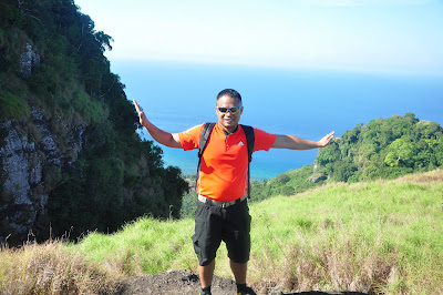
This is my photo at the summit of Bud Bongao. In the horizon behind me is the land of Sabah in Eastern Borneo.


